Intranet | Webmail | Forms | IITK Facility
![]()
![]()
![]()
![]()
![]()


Research
Indicative List of Areas of Interest
|
1 |
Precise geodetic techniques for polar motion studies and in the determination of Earth rotation parameters |
|
2 |
Estimation of essential climate variables using geodetic sensors |
|
3 |
Determination of precise gravity field using satellite gravity missions such as GRACE, GOCE, CHAMP, etc., and hence to realize precise gravimetric Geoid in combination with Airborne and terrestrial gravity data |
|
4 |
Recovery of temporal variations of the gravity field from GRACE and GRACE-FO |
|
5 |
Simulation studies for future satellite gravity field missions |
|
6 |
Characterizing catchments with terrestrial gravimetry |
|
7 |
Development of regional precise gravimetric Geoid for the Indian subcontinent and establish Indian vertical datum. |
|
8 |
Use of precise geodetic techniques for crustal deformation and plate motion studies and in the determination of earthquake precursors |
|
9 |
Satellite altimeter for sea-level variation studies and climate modeling |
|
10 |
Disaster management studies such as flood modeling, Tsunami warning, and landslides using satellite images and satellite/ ground-based geodetic measurement techniques |
|
11 |
Development of Indian grid reference system on GPS along with subroutines for coordinates data computation |
|
12 |
Error analysis in map projection and transformation |
|
13 |
Positioning algorithms for GNSS satellite systems- GPS, GLONASS, GALILEO, COMPASS, IRNASS, etc. |
|
14 |
GNSS reflectometry of soil moisture and sea-level studies |
|
15 |
Crustal deformation studies using GNSS |
|
16 |
Application of the IGS Station at IIT Kanpur for studies on the realization of ITRF and ICRF |
|
17 |
Monitoring the hydrological load using GNSS |
|
18 |
Development of low-cost GNSS permanent stations |
|
19 |
Hydrological modeling using GRACE data |
|
20 |
Use of machine learning techniques with massive data from various geodetic sensors |
|
21 |
SAR interferometry for deformation studies |
|
22 |
Airborne and terrestrial laser scanning for various applications |
|
23 |
Integration of various sensors for navigation and mapping |
|
24 |
Camera calibration for photogrammetric applications |
|
25 |
Mobile mapping systems |
|
26 |
GIS applications in open source environment |
|
27 |
Applications for Earth observation and geosciences |
About
|
Motivation
The NCG was initially conceived on account of limited education in Geodesy at the national level. Although courses on Surveying and Mapping, Geoinformatics, Remote Sensing/ GIS, etc. are being taught at a few universities, none delve into the fundamentals and advanced concepts in Geodesy. Further, national expertise in areas such as Geodesy and SAR interferometry, is rather limited. Thus, there is a need for the development and training of human resources in the aligned areas.
Vision
To act as the hub of excellence in teaching and research in Geodesy at the national and international level by way of preparing well-trained human resources at post-graduate level, quality publications in reputed journals and through collaborative research with international institutes/institutions to contribute in the infrastructure development of the country. |
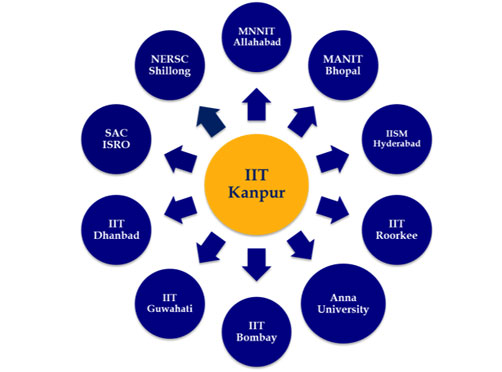
The proposed structure of NCG with IIT Kanpur as the central hub and other institutes as local centers.
|
||||||||||||||||||||||
|
Objectives Supported by the Department of Science and Technology, Ministry of Science and Technology, the primary objective of the NCG is to nucleate and strengthen activities in the area of Geodesy education, capacity building and academic research and development by:
|
Mandate
|