Intranet | Webmail | Forms | IITK Facility
![]()
![]()
![]()
![]()
![]()
International Collaborations
|
1. Validation of combined gravity model EGM2020 Chair: Srinivas Bettadpur (USA) Affiliation: IAG commission 2 Status: Active (2017-2021) Objectives: The main objective of this working group is to validate EGM2020 and preliminary versions of it, to identify potential deficiencies and propose model improvements in different regions of the world. For this independent external validation, a full arsenal of validation methods and external independent data sources shall be applied. This includes validation against GPS/levelling observations, regional data bases of gravity field functions, other global and regional gravity field models, orbit tests to assess mainly the long wavelengths of the field as well as the spectral transition from satellite to terrestrial data, assessment in the frame of mean dynamic ocean topography computations, correlation analysis with topographic potential and isostatic potential models, etc. Potential deficiencies in the preliminary versions of the model shall be identified, in order to improve the model until its final release in 2020. Additionally, the plausibility and consistency of the uncertainty estimates (variance-covariance information) provided together with the model shall be assessed |
|
2. Forward gravity field modelling of known mass distributions Chair: D. Tsoulis (Greece) Affiliation: IAG commissions 2, 3 and GGOS Status: Proposed (2019-2023) Objectives: · Examine new theoretical developments (numerical, analytical or spectral) in expressing the gravity signal of ideal geometric distributions · Perform validation studies of precise terrain effects over rugged mountainous topography · Compute the gravity effect of structures in the Earth's interior and embed this effort in the frame of a Synthetic Reference Earth Model |
|
3. High-resolution harmonic series of gravitational and topographic potential fields Chair: S. Claessens (Australia) Affiliation: IAG commission 2 and GGOS Status: Proposed (2019-2023) Objectives · Develop and compare combined full least-squares, block-diagonal least-squares and quadrature approaches to very high-degree and order spherical, spheroidal and ellipsoidal harmonic analysis. · Develop and compare methods to compute high-resolution harmonic potential models using ellipsoidal geometry, either in terms of spherical, spheroidal or ellipsoidal harmonic series. · Study the divergence effect of ultra-high degree spherical, spheroidal and ellipsoidal harmonic series inside the Brillouin sphere/spheroid/ellipsoid. · Study efficient methods for ultra-high degree and order harmonic analysis (the forward harmonic transform) for a variety of data types and boundary surfaces, as well as harmonic synthesis (the reverse harmonic transform) of various quantities. |
|
4. Regional sea level and vertical land motion Chair: Roelof Rietbroek (Germany) Co-Chair: Riccardo Riva (Netherlands) Affiliation: IAG commissions 2, 4, IAG sub commission 2.6, GGOS and Inter-Commission Committee on “Geodesy for Climate Research” Status: Proposed Objectives: · Encourage the use of geodetic datasets for multi-disciplinary studies related to sea-level · Communicate the need for a consistent treatment of observations and models of sea · Advance the science of regional and global sea-level research by identifying open · Communicate and coordinate activities with other relevant working groups (specifically: |
|
5. IAG sub-commission 2.4e: Gravity and geoid in the Asia-Pacific Chair: Cheinway Hwang (Taiwan, ROC) Co-Chair: Wenbin Shen (Mainland China) Affiliation: IAG commission 2 Status: Proposed (2019-2023) Objectives: a) Gravity and related Data · Share available gravity data · Share available DEMs along common borders · Combine resources for terrestrial gravity surveys along common borders · Promote regional airborne gravity surveys · Determine improved coastal gravity anomalies from satellite altimetry b) Gravimetric geoid and hybrid geoid quality control · Share GNSS/levelling and vertical deflection data for geoid quality control · Promoteregional GNSS/levelingand vertical deflection campaigns · Connect regional vertical datums c) Education & Research · Organize meetings and workshops toimprove modeling and evaluation techniques of gravimetric quasi/geoids, and to promote their application to height modernization and vertical datum connection. · Propose technical sessions in scientific and professional conferences · Propose matters of common concern/interest. |
Introduction of VLBI Technique for Geodetic Applications in India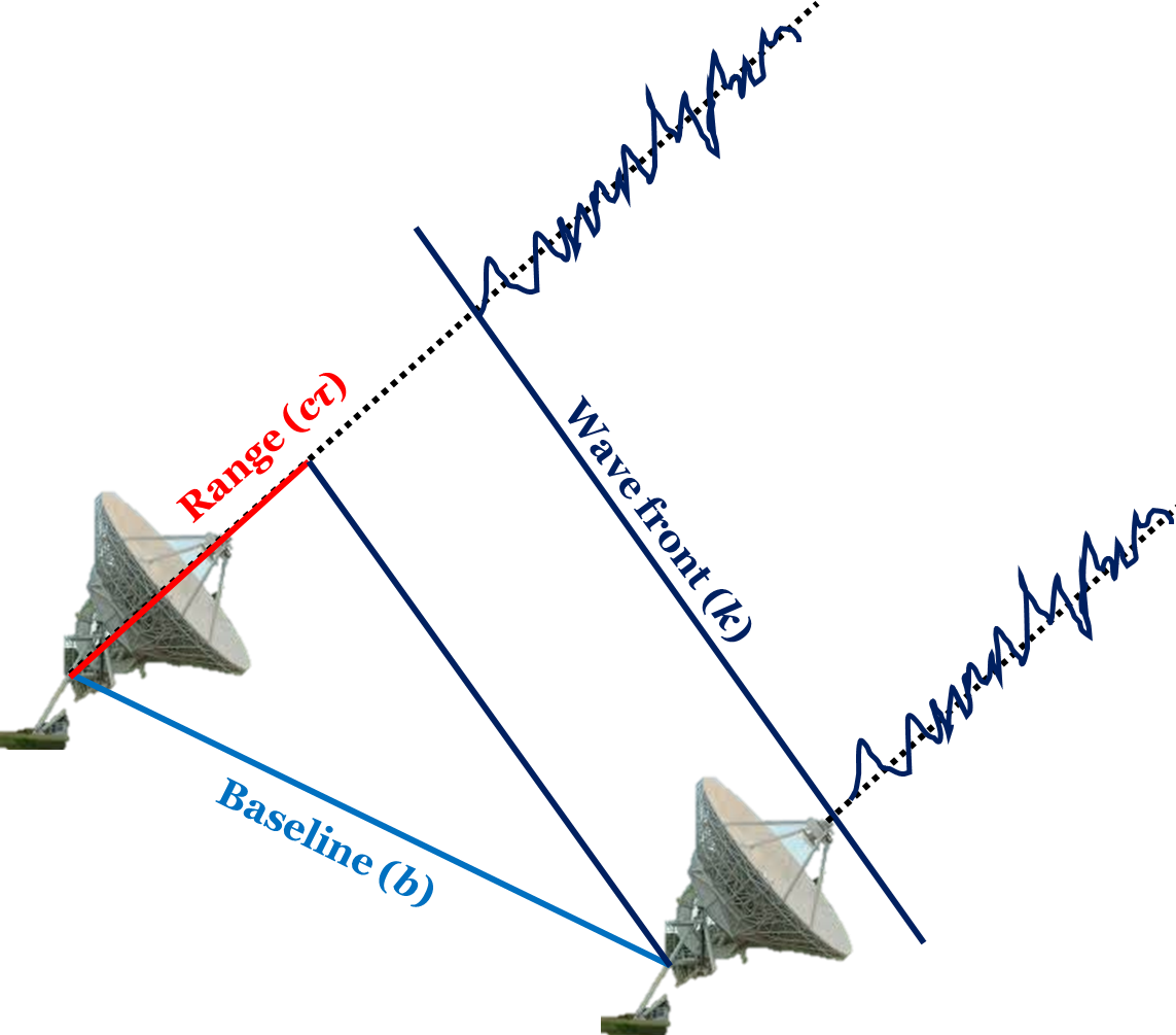
Employment of Very Long Baseline Interferometric Technique for Geodetic Applications is not new to the International Geodetic Community. With the unprecedented precision and resolution made possible by VLBI, various tasks such as geodetic positioning, reference frames interconnections, Earth rotation monitoring, estimating the crustal movements, and mapping the extra-galactic radio sources, have attained accuracies of the levels never reached before.
Initiatives were taken first in June 2006 at BARC, Mumbai and again in January 2007 at NCRA, Pune for deciding the action to be taken for Introduction of VLBI Projects in India. The meeting was attended by experts from NCRA-TIFR, ISRO, SOI, BARC, ECIL, NGRI, RRI, PRL, Various IITs and other organisations. Contributions of Prof. Ananthakrishnan of NCRA, Pune, Dr. EC Malaimani from NGRI, Dr. VK Kulkarni from NCRA, Dr. Subramania from RRI, Shri YS Mayya from BARC/ECIL, and Shri CHVRS Gopala Krishna from ECIL, Hyderabad are worth mentioning in these meetings. However, due to various organisational and administrative reasons, it couldn’t be continued further.
Objectives of the workshop are as follows:
• To introduce the Geodetic VLBI Technique capabilities to Indian Scientific community in areas where it will make an impact (tectonic motion of Indian plate, co-location of VLBI and GNSS antenna, Determination of EOPs for realization of ITRF and ICRF, etc.)
• To facilitate interaction among various national and international organizations to list down the advantages that will accrue due to Introduction of Geodetic VLBI Technique in India.
• To finalise a multi-organisational proposal for setting up of VLBI stations in India.
The workshop will be headed by International expert Professor Harald Schuh, TU Berlin. He has been working in VLBI for past 30 years. He is the Past President of International VLBI Service (IVS) and International Association of Geodesy (IAG).
The prospective participants may register for tis workshop here.
|
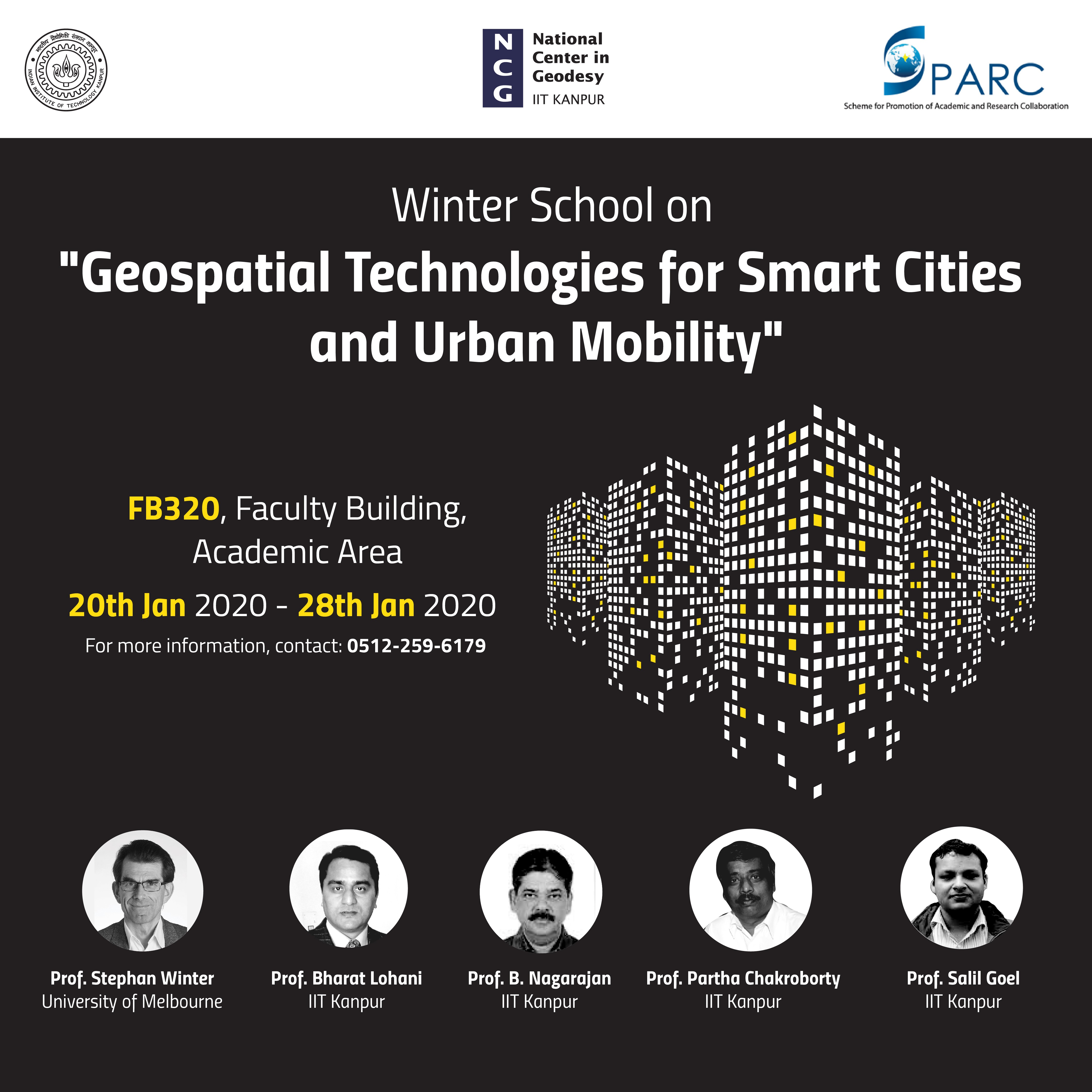
Geospatial Technologies for Smart Cities and Urban Mobility
Geoinformatics Laboratory, Department of Civil Engineering, IIT Kanpur is organizing a winter school on 'Geospatial Technologies for Smart Cities and Urban Mobility' from January 20 - 28, 2020. This school will include talks and lectures from faculty experts as well as from industry personnel. The broad topics that were covered during this winter school include:
1) Future Urban Mobility - Prof. Stephan Winter, The University of Melbourne, Australia 2) IoT, Urban Transportation and Parking spaces - Prof. Partha Chakroborty, IIT Kanpur 3) LiDAR for smart cities - Prof. Bharat Lohani, IIT Kanpur 4) Global Navigation Satellite Systems - Prof. B. Nagarajan, IIT Kanpur 5) Navigation in Urban Environments - Prof. Salil Goel, IIT Kanpur
This school included various case studies that are presented by professionals from industry including Cisco, ESRI, ERDAS and Trimble. This school was particularly useful for the students of Geoinformatics, Transportation and other students who are using geospatial technologies in their research. |
The present and future of Satellite Gravimetry:
Workshop on the design, development and applications of satellite gravimetry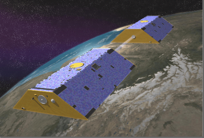 With the impending climate change and increasing stress on freshwater, there is a dire need for monitoring and managing water resources. The twin-satellite missions GRACE and GRACE-FO have contributed immensely in this endeavour for nearly two decades now. However, the spatio-temporal coverage of the missions limit the applicability of the GRACE (-FO) data to regional and global studies. Given the potential of the data for water resources monitoring and management, a number of efforts in terms of algorithms, mission design concepts and instrumentation are being taken to improve the spatio-temporal resolution. It is slowly becoming a multi -national effort wherein space agencies of different countries, especially NASA, USA; ESA, Europe and CNSA, China have been mulling over a joint mission with multiple satellite pairs in orbit.
In this context, we would like to invigorate Satellite Gravimetry research in India, and there by, contribute to this global endeavour given the long-standing expertise and contribution of ISRO, India to earth observation. In order to realize this we would like to conduct a workshop on the next generation gravity-field missions (NGGMs) to bring together the global players in NGGMs and the Indian researchers who are involved in various aspects of Satellite Gravimetry and its applications as well as satellite technology.
|
MoUs |
|
|||
|
|
1. Survey of India (SoI) Regarding: Supplying Topographic Data to Central/State Government Ministries/Organizations/ Agencies without cost as per Pricing policy Under National Map Policy- 2005 Status: MoA finalised by both parties and signed |
|
||
|
|
2. Survey of India (SoI) Regarding: Broad areas of academic and research collaboration is Geoinformatics and Geodesy. Status: MoU under finalization by both parties Objectives: a) Promoting interaction in mutually beneficial R&D areas b) Providing training to SoI Officers and initiating closer academic interaction Facilitating academically eligible Officers from SoI to pursue higher degrees, e.g. DIIT, MS (R)/MTech, PhD, at IITK as per its prevailing norms. |
|
||