|
The contemporary scientific community has developed a nascent awareness and
growing interest in the role of natural forces in shaping the landscape. Floods
are one of the most important natural phenomenon in the alluvial plains and
there have been attempts at developing scientific method linking forcing
function, processes and resultant landform. The emphasis on geomorphological
understanding of floods has increased manifold during the recent years and there
have been attempts to quantitatively relate the geomorphologic parameters with
river discharge.
The plains of north Bihar are some of the most susceptible areas in India prone
to flooding and have recorded the highest number of floods during the last 30
years. The total area affected by floods has also increased during these years.
Drained by two major rivers, the Kosi and Gandak, and several smaller system
such as Burhi Gandak, Baghmati and Kamla-Balan, the plains of North Bihar have
experienced extensive and frequent loss of life and property over the last
several decades. A detailed study of the flood hazard in the Baghmati plains has
been undertaken at IIT Kanpur with a view to understand the causative factors of
flooding in specific reference to geomorphology.
Flooding in the Baghmati River basin is a regular phenomenon, inundating about
2370 km2 of area in the plains out of its total basin area of 8848 km2 (GFCC,
1991), and is reflected in its hydrological characteristics (see Table below). The
data show that the bankfull discharge of the Baghmati River at both upstream and
downstream stations is far less than the other discharge parameters. The
comparison of mean annual flood and bankfull discharge of the river at upstream
and downstream stations shows that at both the stations mean annual flood
exceeds the bankfull discharge. This implies that overbank flooding (spilling)
is a frequent occurrence in the area, at least every second year (on average).
Flood hydrology of the Baghmati river
|
Parameter |
Dhengbridge (Upstream)
(m3/sec) |
Hayaghat (Downstream)
(m3/sec) |
|
Average Annual Discharge (Qm) |
156
|
189
|
|
Bankfull discharge (Qb) |
1100 |
870 |
|
Max. Observed Discharge (Qobs) |
3033 |
2617 |
|
Most probable flood (Qmp)
(T= 1,58 yrs.) |
1155 |
834 |
|
Mean annual flood (Qma)
(T=2.33 yrs.) |
1473 |
1076 |
|
Maximum probable flood (Qmax)
(T= 10,000 yrs.) |
6212 |
5051 |
Qmp- Peak
discharge corresponding to a return period of 1.58 years.
Qma - Peak
discharge corresponding to a return period of 2.33 years.
Qmax - Peak
discharge corresponding to a return period of 10,000 years.
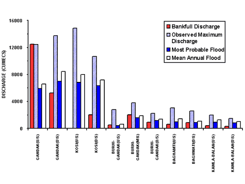
Apart from Baghmati, all other rivers in north Bihar Plains are also prone to
overbank flooding.(see Figure) Comparing the mean annual flood at upstream and downstream
stations, the Gandak and Burhi Gandak show a higher value at downstream station.
The Kosi River shows an altogether different picture and using similar
interpretation, the flooding would be more intense at the upstream station (Birpur)
than at downstream station (Baltara). The Kosi being a typical fan system has a
number of distributary channels in downstream reaches because of which flood
peaks are attenuated between Birpur and Baltara. In the Burhi Gandak River, the
midstream station (Sikanderpur) shows higher values of peak discharge at all
return periods. Once again, the increase in peak discharge between Chanpatia and
Sikanderpur can be explained due to tributary influence. No major tributary
seems to be joining the Burhi Gandak between Sikanderpur and Rosera and
therefore flood peak is being attenuated. At all stations, the Qmp is lower than
bankfull discharge but Qma is higher than bankfull discharge implying thereby
that the river would flood every alternate year (on average).
Comparison of discharge parameters of interfan rivers
Apart from the frequency of floods, the extent of flood at both stations is
severe, which is assessed from the difference of flood level and the danger
level. The flood level above the danger mark (maximum depth of inundation)
averages around 1-1.5 meters but has been recorded as high as 2.5 to 3 meters in
some years, particularly at the downstream station. The variation of
flood level is apparently a function of the actual location of the breach and overbank spilling in a particular year. Further, the average period of
inundation is around 30 days as informed by the local people and as suggested by
the available data (see Figure below). The period 1970-75 is particularly bad during which
the floodwater has taken as long as 100 days to recede.
|

(a)
|

(b)
|
 |
Flood affected regions are not uniformly distributed over the
entire basin but are localized to certain pockets, which points to the
control of geomorphological factors on flood hazard. Major flood-prone
windows in the Baghmati river basin include the areas around Bairgania,
Sheohar, Katra, and Kalanjarghat to Hayaghat. These windows were
selected for detailed study of flooding behaviour and causative factors
using a remote sensing approach (Jain
& Sinha in press(1)).
An integrated approach employing remote sensing data coupled with DEM,
hydrological study and field observations is recommended to understand the
causative factors of flooding using the example of the Baghmati river basin
in eastern India.
The study has shown that the tributary influence, topographic
control, abandonment of channels and neotectonics in the basin area are the
major reasons for the flooding in the study area. The remedial measures such
as small check dams and afforestation work in the upstream basin area may be
more effective in reducing the flood hazard in the region.
Click on the windows, to see more details
The Baghmati River basin as seen on satellite image (IRS LISS II, band 4) of
February 1989. Boxed area are flood-prone windows.
|
|
Flooding is responsible for extensive damage to lives and property every year
(see Table and figures below). Annual variation in flood hazard is quite variable and
unpredictable; however 5-yr average flood shows a sharp increase from 1969 to
1973 (Figure). On an average, the floods in Baghmati River affect over a lakh
hectares of area annually and during the period 1971-90 the total annual flood
damages have varied from a minimum of 6 crores to a maximum of 30 crores of
rupees. The total damage during this period of 20 years is of the order of a
whopping 60 crores. This obviously spells out an urgent need to develop better
strategies for flood prediction as well as protection in the region. The trend
of the flood damage shows that the flood affected area and flood affected
population in Baghmati River basin are quite variable. However, all the other
parameters of flood damage show that the maximum damage had occurred in 1987.
Peak discharge data does not show a very high peak at any station in 1987, but
average monthly discharge shows the higher peak in 1987 (September, 1987) at
downstream station (Hayaghat). It shows that the flood damage is not directly
related with the peak discharge observed at particular station, whereas it
depends upon the closeness of location of flooding with the population
concentration and public places.
Flooding Problem in the
Baghmati River Basin
|
FLOOD PROBLEM
|
1971-1975 |
1976-1980 |
1981-1985 |
1986-1990 |
|
1. Maximum discharge recorded (cumecs)* |
2617.96 ** (1975) |
1220.93 (1978) |
2106.44 (1984) |
1491.17 (1987) |
|
2. Average annual crop area
affected (in lakh ha.) |
1.024 |
0.4087 |
0.389 |
0.488 |
|
3. Average total area affected (in
lakh ha.) |
1.131 |
0.9484 |
0.839 |
0.907 |
|
4. Average annual damages to crops
(in Rs. lakh) |
3960.66 |
675.31 |
728.06 |
824.60 |
|
5.
Average annual damages to private properties (in Rs. Lakh) |
346.18 |
71.02 |
41.09 |
298.88 |
|
6.
Average annual damages to public utilities(in Rs. lakh) |
78.28 |
0.80 |
33.94 |
266.07 |
|
7. Average annual total flood
damages ( in Rs. lakh) |
2970.75 |
748.33 |
620.06 |
1389.56 |
* peak discharge values at downstream
station (Hayaghat) is taken
** in this period (1971 -75), the peak discharge data is available only for 1975
(Source:
Ganga Flood Control Commission, 1991)
Affect of flood |
Population affected |
 |
 |
House damages |
Number of losses to live |
 |
 |
|
Loss of public
utilities |
Total loss due to flood
(prices of 1990) |
 |
 |
Note: year 1987 is
characterized by maximum damage in the Baghmati River basin. The less
correlation of damage data with the peak discharge data is showing that
location of breaching is more important in flood hazard analysis rather than
the peak discharge value in the particular year.
|
|