Interfan area
The area between the two fans is considered as a distinct geomorphic setting
in its own right. The river systems draining these areas and the sedimentary
architecture developing below are characteristically different from the fan
areas. One of the best described interfan area in the Gangetic plains is the
Gandak-Kosi interfan in north Bihar plains, eastern India.
Study area description - Gandak-Kosi Interfan
 |
-
-
|
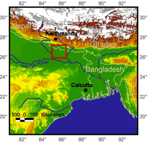
Our representative
interfan area is located between the
Gandak and Kosi magafans, north Bihar plains, eastern India. The interfan area
is drained by a number of smaller rivers i.e. Burhi Gandak, Baghmati and
Kamla-Balan rivers. Geddes (1960) provided the first detailed geomorphic map of
the area and was able to demonstrate the subtle topographic differences between
the megafans and the interfan area. In terms of source area classification (Sinha
and Friend, 1994), the interfan areas are drained by ‘foothills fed’ (e.g.
Baghmati) and ‘plains-fed’ river system (e.g. Burhi Gandak) and are flanked by
the ‘mountain-fed’ river system (e.g. Kosi and Gandak) to the east and west.
These river systems show distinctive morphological and hydrological
characteristics. The mountain fed rivers are characterized by high discharge and
these are essentially bed-load rivers with a braided morphology throughout their
course. The foothills fed and plains-fed rivers generally show meandering
morphology, the former with moderate discharge and high sediment concentration
and the latter with low discharge and fairly high sediment concentration. The
flood plains of these rivers are affected by frequent channel migration through
avulsion and cutoffs.
|