|
The Indo-Gangetic basin is an active foreland basin having east west
elongated shape. The basin formed in response to the uplift of Himalaya after
the collision of India and China plates (Dewey and Bird, 1970). Suess
(1893-1909) was the first to suggest that the Indo-Gangetic depression is a
‘fore-deep’ and was formed in front of the high crust-waves of the Himalayas as
their southward migration was resisted by the rigid landmass of the Peninsula.
The sedimentation in the basin started with a shallow marine environment, which
changed to estuarine and deltaic one with time. By Mid-Miocene, the
sedimentation was dominated by fluvial environment and it continued to the
recent. Sedimentation in the basin was influenced by tectonism throughout its
evolution (Parkash and Kumar, 1991).
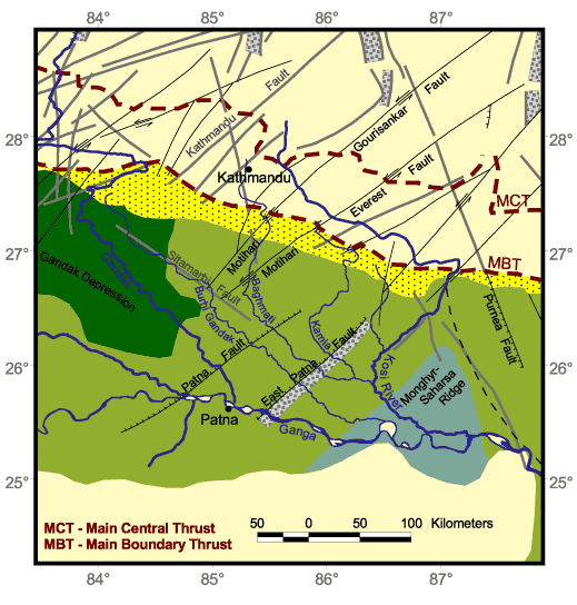
On the basis of the gravity data, seismic surveys and deep drilling data from
the Gangetic foredeep, some basement faults have been demarcated by various
workers (Sastri, et al. 1971; Rao, 1973; Karunakaran and Rao, 1976; Agrawal,
1977; Mukhopadhyay, et al., 1986; Verma et al., 1988; Dasgupta, 1993). These
investigations clearly bring out two types of basement faults that are present
below the foredeep alluvium cover. One set of faults orient sub-parallel to the
Himalayan trend and the other is transverse to it. In the north Bihar region,
the important faults are West and East Patna faults in the East Ganga Basin and
the Monghyr–Saharasa Ridge with its bounding faults i.e. one passing through
Rajgir and Barauni towards the NE and the other from east of Bhagalpur towards
N/NNW. These faults are known as transverse faults, as the trend of these faults
is transverse to the trend of Himalayan faults (Valdiya, 1976; Dasgupta et al.,
1987). These transverse faults were formed during a rifting phase immediately
before or contemporaneous with Permo-Carboniferous Gondwana sedimentation (Dasgupta,
1993). These transverse faults in the Himalayan region vary in direction form NW
to NE direction and form a set of conjugate faults. Dasgupta et al.(1987)
interpreted that the northward movement of Indian plate is causing the
activation of these subsurface transverse fault and added that a substantial
part of convergence of Indian plate is accommodated by strike-slip motion across
the Himalaya, in addition to normal faulting in certain areas.
Another set of E-W trending faults has been recorded only in the western part of
the Gangetic plain (Hari Narain and Kaila, 1982; Srivastava, et al., 1983).
There is a possibility of occurrence of roughly E-W trending subsurface faults
in the eastern Gangetic plain below the Gangetic foredeep, close to the mountain
front (Dasgupta, 1993). Reactivation of these faults is possible in response to
the Himalayan tectonics. These faults are perhaps the oldest and originated
during the Precambrian (mid Proterozoic) period as possible passive margin
normal faults (Hari Narain and Kaila, 1982; Srivastava, et al. 1983, Dasgupta,
1993).
Besides these subsurface faults, some surface faults have also been reported
from the alluvial fan area of north Bihar Plains. The surficial faults in and
around Gandak megafan include Rohini fault, Gandak fault, Rapti fault and
Ghaghra-Ganga Fault (Raiverman et al., 1983; Mohindra et al., 1992). The Gandak
River is following the Gandak fault, which is trending NW-SE. Mohindra et al.
(1992) have also inferred that the flood basin area in between the Burhi Gandak
River and Kosi River is tectonically active and rapidly subsiding. Gohain and
Parkash (1990) have worked on the Kosi alluvial fan and presented the geological
map of the Kosi fan and the adjoining area. The map shows two large-scale
thrusts trending in the NE-SW direction and NW-SE direction. Also, several other
active faults are shown in the adjoining area of the Kosi megafan. Agarwal and
Bhoj (1992) also interpreted several NNW-SSE and NNE-SSW trending faults in the
Kosi River basin on the basis of remote sensing and geophysical studies. In
general, the north Bihar Plains provide an opportunity to study the fluvial
geomorphology in a subsiding basin.
Occurrence of earthquake indicates the tectonic instability in the area and
suggests that the faults are presently active. The earthquake activity in the
Himalaya is attributed to the Alpine–Himalayan seismicity belt. Most well
located epicenters reported after 1961, are concentrated in a 50 km wide zone,
between MBT and MCT in the Lesser Himalaya, mainly south of MCT. On a regional
scale, the seismic data reflects that the Nepal and Sikkim Himalaya and its
foredeep region (which includes north Bihar Plains) are quite active
tectonically. This area has recorded 131 seismic events (source: ISC Bulletin,
in Dasgupta et al., 1987) during the period of 1963-1980. In the last 100 years
few great earthquakes have occurred in the Himalaya, affecting the north Bihar
region.
The Bihar-Nepal earthquake of August 26, 1833 was a violent earthquake of
Magnitude 7.0-7.5 (Dunn, et al., 1939; Mittal and Srivastava, 1962). However,
not much information is available of this earthquake. Another, earthquake of
Magnitude 8.4 (approx.), occurred on 15th January 1934, with its epicenter at
latitude 26021 N, longitude 86012 E. It was located south of MBT (Dunn et al.,
1939). Recently, a major earthquake measuring 6.6 on Richter scale with its
epicenter close to Bihar-Nepal border shocked the northern Bihar and Nepal
region on August 21, 1988.
|